When you look at a live flight tracker, you might notice something odd:
Some aircraft fly long curves, zig-zag lines, detours, or routes that look completely wrong.
So why don’t airplanes always fly in a straight line?
In reality, every “strange” flight path is the result of safety, efficiency, weather, geopolitical rules, or air traffic management. This guide breaks down the real reasons why aircraft sometimes take unusual, unexpected routes.
1. The Earth Is Round — Straight Lines Look Curved on Maps
The most common “strange route” is actually completely normal.
Airplanes fly along Great Circle Routes, the shortest path between two points on a spherical planet.
On a flat map:
- The route looks curved
- It may even look like the plane is going the wrong direction
But in reality:
- It’s the most fuel-efficient path
- Long-haul flights always follow these arcs
This is why flights like London → Los Angeles or Dubai → Seattle appear to bend over the Arctic.
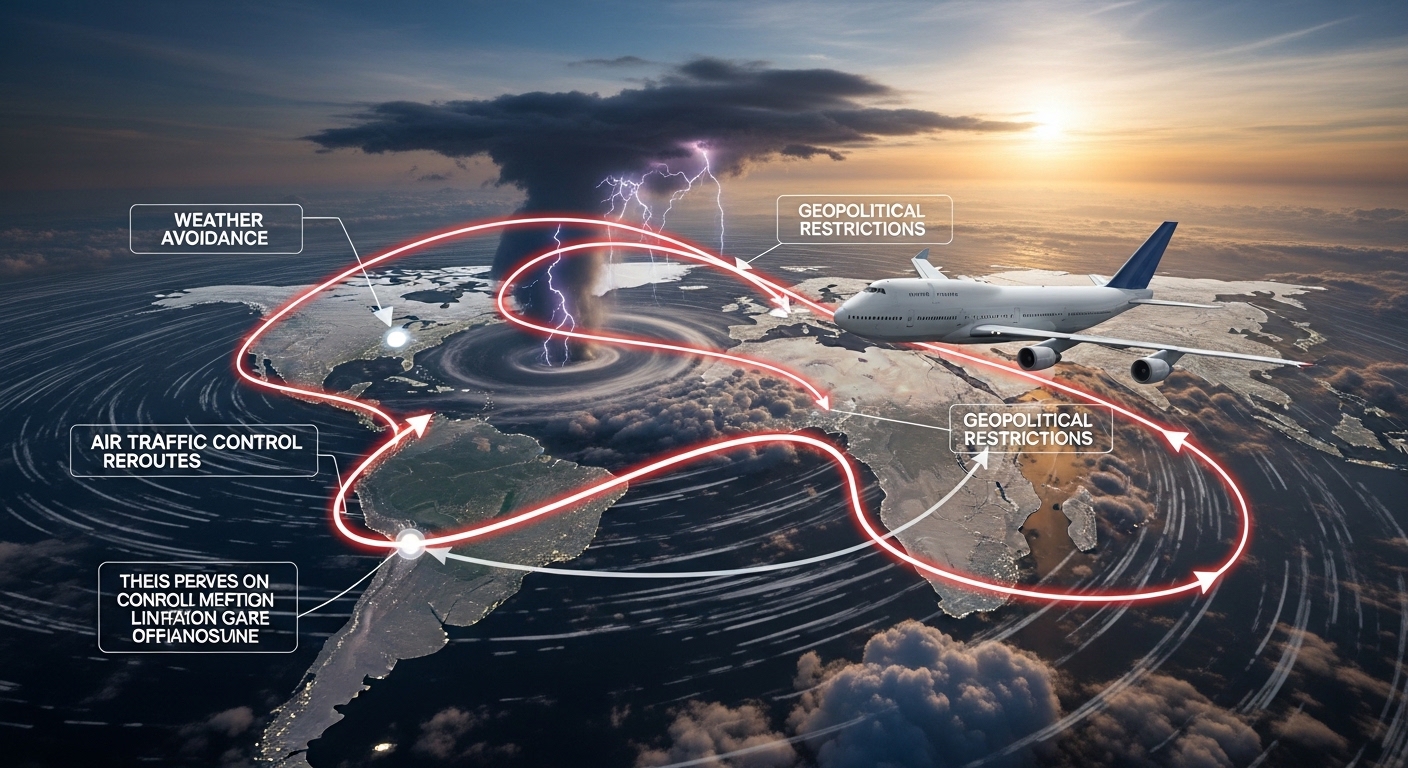
2. Weather Avoidance (Storms, Turbulence, Jetstreams)
Weather is one of the biggest reasons aircraft deviate from expected paths.
Aircraft avoid:
- Thunderstorms
- Turbulent zones
- Heavy headwinds
- Volcanic ash
- Icing layers
- Tropical cyclones
Example: During monsoon season or winter storms, flights routinely make long detours to avoid dangerous weather cells.
Jetstreams also influence routes
Westbound flights often avoid strong jetstream winds, while eastbound flights ride them for speed and efficiency.
3. Restricted Airspace & No-Fly Zones
Many regions of the world are restricted or dangerous for civilian aviation.
Planes cannot fly over:
- Active war zones
- Military operation areas
- Sensitive borders
- Nuclear sites
- Politically restricted regions
Examples:
- Flights avoiding Russian, Ukrainian, Syrian, or North Korean airspace
- Indo-Pak border avoidance
- U.S. restricted zones like Washington D.C. P-56
These restrictions can cause major detours.
4. Air Traffic Control Instructions
Air Traffic Control (ATC) ensures safe aircraft separation.
Sometimes that requires routing changes.
ATC may alter routes for:
- Traffic congestion
- Emergencies
- Spacing during landing
- Delays on congested airways
- Weather diversions nearby
This often results in unusual “S-shaped” or “looping” routes.
5. Navigation Waypoints & Structured Airways
Airplanes cannot fly freely everywhere—they must follow pre-defined airways, like highways in the sky.
These airways are built around:
- Radio navigation beacons
- Waypoints
- Terrain
- Country boundaries
- International flight corridors
Older aircraft especially follow rigid navigation paths, leading to zig-zag-looking routes.
6. Fuel Optimization & Cost Efficiency
Airlines sometimes choose a longer path if it saves fuel.
For example:
- Avoiding strong headwinds
- Choosing a slightly longer but smoother jetstream corridor
- Optimizing flight levels for fuel burn
AI-powered optimization tools can create flight plans that look strange but save thousands of dollars in fuel.
7. Avoiding Mountains or High Terrain
Routes near the Himalayas, Andes, Alps, Rockies, or Alaska may appear odd because aircraft need to stay clear of:
- Extreme terrain
- Turbulence zones
- Icing layers
- Limited emergency landing options
This is especially common for long-haul flights over remote terrain.
8. Emergency Diversions or Medical Issues
A sudden route change—often a sharp turn—can mean:
- A medical emergency
- Aircraft technical issue
- Cabin pressurization problems
- Passenger requiring urgent landing
These situations force planes to divert to the nearest suitable airport, creating unusual paths on tracking apps.
9. Military Activity or Temporary Flight Restrictions (TFRs)
Some detours happen because the military temporarily closes an airspace segment.
Examples:
- Missile tests
- Military exercises
- VIP/diplomatic movement
- Major events (e.g., Olympics, G20, UN summits)
These temporary zones force aircraft to reroute around them.
10. Long Polar Routes & Emergency Airports
Polar flights appear strange because they:
- Avoid intense radiation zones
- Need access to emergency airports
- Must manage extreme cold impacts on fuel
Some routes deliberately avoid deep Arctic zones if solar storms are active.
11. Oceanic Separation Rules
Flights over the Atlantic, Pacific, and Indian Oceans follow special tracks called:
- NAT Tracks (North Atlantic Tracks)
- PACOTS (Pacific Organized Tracks)
- AUSOTS (Australian Tracks)
These appear curved, shifting daily based on jetstream movements.
Aircraft cannot fly direct routes because oceanic ATC has limited radar coverage.
12. Aircraft Performance Limits
Planes sometimes detour because of performance constraints:
- Maximum altitude limits
- Engine-out diversion rules
- ETOPS certification
- Weight restrictions
A heavily loaded aircraft may choose a different, longer climb route before reaching cruise altitude.
Frequently Asked Questions (FAQ)
Q1: Why does my flight fly north to go west?
Because Great Circle routes curve on a flat map—it’s actually the shortest path.
Q2: Why do some flights take big detours over water?
Due to oceanic airways, winds, and limited ATC radar coverage.
Q3: Why do flights avoid certain countries?
Due to war zones, political restrictions, or safety concerns.
Q4: Why do planes sometimes turn back after takeoff?
Mechanical issues, medical emergencies, or performance limitations.
Q5: Why don’t airplanes always fly in a straight line?
Because of weather, ATC, safety, airspace restrictions, and the Earth’s curvature.
Conclusion
When a plane takes a strange or unexpected route, it’s rarely a mistake—it’s almost always a carefully planned decision for safety, efficiency, and compliance with global aviation rules. From weather and geopolitics to performance and air traffic control, every curve and detour in the sky has a purpose.
Understanding these factors helps aviation fans, passengers, and flight-tracking users make sense of the dynamic path every aircraft takes across the skies.