Tracking a domestic flight is usually simple: pull up a flight tracker, search the flight number, and watch the dot move across the map without much drama. International flights are a different story. Long-haul routes cross oceans, multiple time zones, and regions with inconsistent tracking coverage which means the same basic process can produce confusing results if you don’t understand what’s actually happening behind that moving dot.
This guide focuses specifically on tracking international flights live: how the technology handles long-haul and cross-ocean routes, which tools handle worldwide coverage best, and the practical adjustments that make tracking an overseas flight far less confusing.
Why Tracking International Flights Is Genuinely Different
Before comparing tools, it’s worth understanding why international tracking behaves differently than a short domestic hop.
- Longer routes cross more airspace jurisdictions, each with different levels of ground-based tracking infrastructure.
- Ocean crossings remove ground coverage entirely for stretches of the flight, requiring satellite-based tracking to fill the gap.
- Time zone changes multiply confusion, since a flight departing at 11 p.m. one day might land at 6 a.m. two calendar days later from the traveler’s perspective, even though the actual flight time was far shorter.
- Code-share flights complicate flight number searches, since an international flight is often sold under multiple airline codes for the same physical aircraft, and tracking the “wrong” flight number can show inconsistent information.
None of this makes international tracking unreliable it just means understanding a few extra variables makes the whole process much less confusing.
How Real-Time International Flight Tracking Actually Works
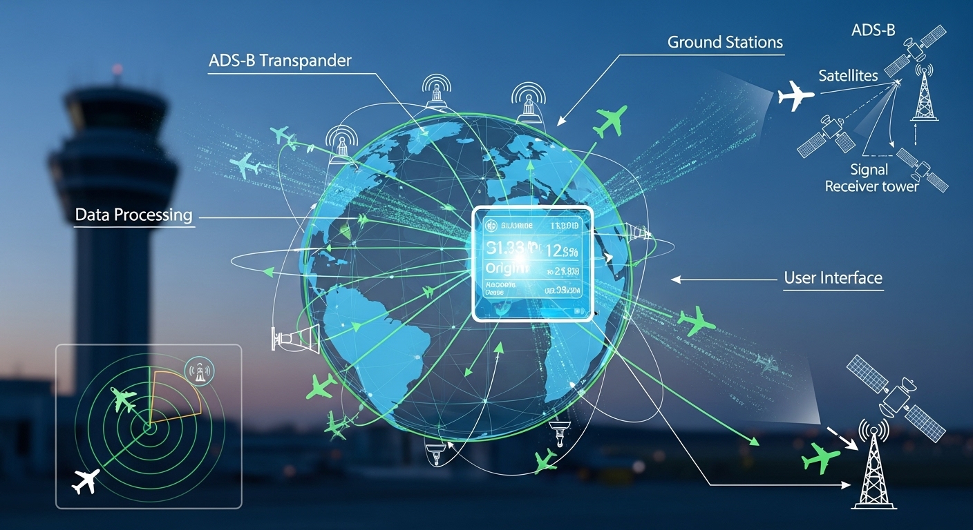
A real time airplane tracking system for international routes typically blends three underlying data sources, each covering a different gap in coverage.
ADS-B ground stations
Most modern aircraft broadcast ADS-B signals GPS-based position, altitude, and speed data picked up by ground receivers within range. This works extremely well over land, especially in regions with dense receiver networks, which is why a flight radar live view usually looks smooth and continuous while a flight is over populated continents.
Satellite-based ADS-B
Once a flight moves beyond ground receiver range over an ocean, for example many modern tracking platforms switch to satellite-based ADS-B, picking up the same broadcast signal from orbit instead of the ground. This is what allows a capable live air traffic tracker to maintain reasonably continuous coverage even across the Atlantic or Pacific, though update frequency can be slightly less frequent than dense ground coverage provides.
Multilateration
In regions with partial ground coverage enough receivers to detect a signal, but not precisely enough for full ADS-B accuracy some systems use multilateration, triangulating an aircraft’s position using the timing differences between multiple receivers picking up the same signal. This fills in some of the middle ground between full ADS-B coverage and total data gaps.
Airline and airport schedule data
Layered on top of all this positional data is standard schedule information from airlines and airports gate assignments, scheduled versus actual departure and arrival times, and delay status. This is what turns a raw moving dot into a complete live flight status tracker experience.
Step-by-Step: How to Track an International Flight Live
Step 1: Get the correct flight number
International flights are frequently sold under multiple airline codes through code-share agreements. If you search a flight number and the results look inconsistent with what you expect, double-check whether you have the operating airline’s flight number or a code-share partner’s number they can refer to the exact same physical flight but return different-looking data depending on the tracker.
Step 2: Search using a live flight tracker online
Use a live flight tracker online tool and search by flight number, or by route and approximate departure time if you don’t have the exact number. Look for a result showing the correct departure and arrival airports to confirm you’ve found the right flight, especially for airlines with multiple daily flights on the same route.
Step 3: Confirm the time zone being displayed
This is the single most common source of confusion for international tracking. Before assuming a flight is delayed or behaving unexpectedly, confirm whether the departure and arrival times shown are in local departure time, local arrival time, or your own device’s time zone many tracking platforms let you toggle this, and it’s worth checking explicitly rather than assuming.
Step 4: Switch to the live map to track flight live
Once the flight is airborne, switch to the live map view to track flight live as it crosses regions. Expect the aircraft icon to move smoothly over land and potentially update less frequently mid-ocean this is normal behavior tied to the underlying tracking technology, not a malfunction.
Step 5: Watch for expected coverage gaps
If the aircraft briefly stops updating mid-ocean or over sparsely covered remote airspace, don’t be alarmed this is a known limitation of current tracking coverage, and the aircraft typically reappears once it re-enters denser coverage or satellite tracking picks the signal back up.
Step 6: Set alerts for hands-off monitoring
Most capable real time flight tracking app options let you save a specific flight and receive push notifications for status changes, so you don’t need to keep manually checking a long-haul flight over many hours.
Live Flight Tracker With Map: Reading an International Route
A properly built live flight tracker with map for international routes typically includes a few features specifically useful for long-haul tracking:
- Full route visualization, showing the entire planned path from origin to destination, not just the current position, which helps you gauge overall progress at a glance
- Altitude and speed detail, useful for understanding cruise phase versus climb or descent, particularly relevant for estimating actual arrival time versus scheduled time
- Time-zone-aware displays, ideally showing both origin and destination local times side by side
- Weather overlays, on more advanced platforms, which can help explain a longer-than-expected flight path if the aircraft is routing around a storm system
Comparing the Best Flight Tracker Apps for International Routes
Not every tracking app handles worldwide coverage equally well. Here’s how to think about the main categories when your priority is specifically international and long-haul tracking.
Free, browser-based trackers
A solid flight tracking app free tier is usually enough for occasionally checking an international arrival say, picking someone up from an overseas trip. Expect basic map view, flight number search, and general delay status, though some free tiers apply a short data delay compared to paid real-time feeds.
Dedicated mobile apps with worldwide coverage
A proper live flight tracker app download built specifically with global coverage in mind tends to handle ocean-crossing routes and less-covered regions more consistently than casual browser tools, and typically offers push notifications that matter more for long flights spanning many hours.
Advanced real-time tracking apps
A more feature-rich real time flight tracking app may include predictive delay estimates, more granular altitude and route data, and richer airport-level detail useful if you frequently fly internationally yourself and want a tool that becomes part of your regular travel routine rather than an occasional lookup.
Enthusiast-grade airplane tracker apps
For genuine aviation enthusiasts, some airplane tracker app and plane tracker live options go further, showing registration numbers, aircraft type detail, and historical flight paths useful for tracking specific long-haul aircraft types or unusual international routings out of general interest.
When comparing options specifically for international use, check whether the platform explicitly advertises global or worldwide coverage, since some tools are notably stronger over North America or Europe and comparatively weaker elsewhere.
Common Mistakes When Tracking International Flights
- Assuming a data gap means something is wrong. Brief tracking interruptions mid-ocean or over remote regions are a known limitation, not a red flag.
- Misreading time zones. Confusing local departure time, local arrival time, and your own time zone is the most frequent source of unnecessary worry.
- Tracking the wrong code-share flight number. Double-check you have the correct operating flight number, especially on codeshare-heavy international routes.
- Relying solely on push notifications for something time-critical. A manual check shortly before an airport pickup is a good habit, since notifications can occasionally lag behind live data.
- Expecting identical update frequency everywhere. Coverage density genuinely varies by region dense over major international corridors, sparser in less-trafficked remote airspace.
Tips for Frequent International Travelers
- Save recurring routes if you regularly track the same international flights a family member’s routine visit, a repeated business trip so you’re not re-searching from scratch every time.
- Cross-check with the airline’s own app for gate and boarding information specifically, since third-party trackers sometimes lag slightly behind an airline’s own real-time operational data for gate-level detail.
- Build in a buffer for connections, since long-haul international delays tend to be longer in absolute time than domestic delays, even if the percentage delay looks similar.
- Use airport-level views for connecting flights, checking the arrivals board at your connection airport directly if your inbound flight is running late, rather than only tracking your outbound connecting flight in isolation.
How Tracking Coverage Varies by Region
Not all parts of the world are tracked with the same consistency, and understanding this helps set realistic expectations before you start watching a specific route.
North America and Europe generally have the densest ADS-B ground receiver networks in the world, largely thanks to a large, active community of volunteer receiver operators alongside commercial infrastructure. Flights within or between these regions tend to show the smoothest, most continuous tracking data available.
Major transoceanic corridors the North Atlantic route between North America and Europe, and the transpacific routes connecting Asia and North America are heavily trafficked enough that satellite coverage and airline-reported positioning tend to be well maintained, even though ground coverage disappears mid-crossing.
Parts of Africa, the Middle East, and Central Asia can show sparser tracking data, simply due to fewer ground receivers in less densely populated or less accessible regions. Flights through this airspace may show longer gaps between position updates, even though the flight itself is proceeding entirely normally.
Polar and extremely remote routes, used by some long-haul flights taking shorter greatcircle paths between distant continents, can show some of the least consistent tracking data of any commonly flown routes, simply due to the near-total absence of ground infrastructure in those regions.
None of this reflects a flight being less safe or less monitored by air traffic control commercial aviation has its own separate, robust monitoring systems independent of what a consumer flight tracker can access. It simply means the public-facing tracking data available to travelers is uneven across the globe, and that unevenness is worth expecting rather than being surprised by.
A Practical Example: Tracking a Transatlantic Flight Start to Finish
It helps to walk through what this actually looks like on a real route. Imagine tracking a flight from New York to London.
Shortly after takeoff, the aircraft appears on the live map with smooth, frequent position updates, since the U.S. East Coast has dense ADS-B ground coverage. As the flight climbs to cruising altitude and heads out over the Atlantic, ground coverage fades, and updates may become slightly less frequent perhaps every minute or two rather than every few seconds as the tracker shifts to satellite-based data for the ocean crossing.
Partway across, you might notice the position update interval lengthen further, particularly toward the middle of the ocean crossing, farthest from both coastlines. This is entirely expected and doesn’t indicate any issue with the flight itself.
As the aircraft approaches the UK and Irish coastlines, ground-based ADS-B coverage picks the signal back up, and tracking returns to frequent, smooth updates for the descent into London. Throughout this entire process, the flight’s actual estimated arrival time pulled from a combination of position, speed, and airline schedule data continues updating reasonably reliably even during the lower-frequency mid-ocean stretch, since that estimate doesn’t require constant repositioning data to stay reasonably accurate.
Understanding this pattern in advance smooth, then sparser, then smooth again turns what might otherwise look like a tracking problem into simply what a normal transatlantic flight looks like on a live map.
Free vs. Paid: What Actually Matters for International Coverage
Deciding between a free tracker and a paid subscription comes down to a few specific questions rather than price alone.
How often do you actually track international flights? If it’s a handful of times a year an occasional overseas trip or picking up a visiting relative a well-regarded free tier is almost always sufficient. The core functionality (flight number search, live map, delay status) tends to be reliable across most reputable free tools, even if paid tiers offer a modest edge in update frequency.
Do you need true real-time data, or is a short delay acceptable? Some free tiers apply a one-to-two-minute delay compared to their paid real-time feed. For casual tracking checking on a flight a few times over several hours this delay is rarely noticeable. It matters more if you’re timing something precise, like an airport pickup planned around the exact landing moment.
Do you need deeper route or aircraft detail? Paid tiers often unlock more granular altitude, speed, and routing information, along with richer historical data for a specific aircraft. This mostly matters for aviation enthusiasts or frequent business travelers who want more than a basic status check.
Do you need reliable push notifications across many hours? Long-haul international flights can run twelve hours or more, and a paid app with dependable notifications can genuinely save you from manually checking a browser tab repeatedly throughout that window.
For most people tracking an occasional international flight, a solid free tool covers the need completely. The upgrade to paid tracking tends to make sense specifically once tracking flights becomes a regular part of how you manage travel, rather than an occasional check-in.
Final Thoughts
Tracking an international flight live isn’t fundamentally different from tracking a domestic one it just involves a few extra variables worth understanding: ocean coverage gaps, time zone differences, and the occasional code-share mix-up. Once you know what’s actually happening behind those brief data gaps and how to read a worldwide live map correctly, tracking a flight halfway across the globe becomes just as straightforward as watching a short domestic hop you just might need to double-check which time zone you’re looking at first.
Frequently Asked Questions
Why does my international flight tracker show a gap over the ocean?
This is expected behavior. Ground-based ADS-B coverage doesn’t extend far over open water, so tracking platforms rely on satellite coverage or multilateration to fill the gap, which can update slightly less frequently than dense ground coverage.
Can I track a flight before it takes off?
Scheduling information is typically available as soon as an airline publishes the flight, often months ahead. Live position tracking only becomes available once the aircraft is airborne, and sometimes while taxiing depending on airport-level ADS-B coverage.
Is international flight tracking as accurate as domestic tracking?
Over well-covered regions, accuracy is comparable. Accuracy can dip briefly over oceans or remote airspace due to coverage limitations, though major international corridors are generally well tracked by modern platforms.
Why do two different tracking apps show slightly different information for the same flight?
Different platforms may pull from different underlying data providers, apply different update delays on free tiers, or in some cases track a codeshare partner’s flight number rather than the operating airline’s number, producing minor discrepancies.
Do I need a paid app to reliably track international flights?
Not necessarily. Many free tiers handle occasional international tracking well. A paid tier becomes more valuable if you fly internationally often and want true real-time updates without delay, richer route detail, or more reliable push notifications.
What’s the best way to track a flight with a layover?
Track each flight segment separately using its own flight number, and consider checking the connecting airport’s arrivals board directly if your inbound flight is delayed, since that gives you a clearer picture of how a delay might affect your connection.